Terrain Modeling
Model a complete site in minutes and export a detailed, to-scale site plan.
A Single Software to Model Terrain and Visualize House Placement
Whether you’re a custom home builder or a renovation pro, Cedreo’s 3D terrain modeling software lets you sketch flat or sloped sites in 2D and visualize them in 3D. You get all the essentials for terrain design so you can produce a finished site plan, including house placement, in 20 minutes.
Speed Up Terrain Modeling
Use intuitive tools and smart automations to draft terrain fast.
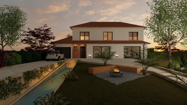
Present Accurate Site Plans to Clients
Create precise plans for any type of terrain so clients can visualize the finished site.
Validate Placement Options
Test scenarios and validate your ideas for building placement.
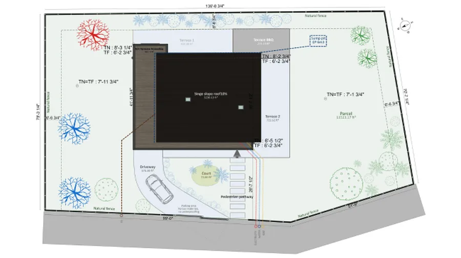
Draw the Natural Terrain
- Import the existing plan: Import the land registry or surveyor’s plan (DWG, DXF, JPEG, PNG, or PDF) and use it as a layer to simplify drawing.
- Draw the plot: Sketch a freeform shape and add setback lines. Terrain surfaces (building footprint and open ground area) are calculated automatically.
- Define terrain orientation: Set the north arrow and customize its display.
- Set elevations (altimetry) by points or elevation lines where you define the height.
- Place the building: Place new or existing structures, control their elevation relative to finished grade, and set a rotation angle.
Design the Site
- Draw driveways: For vehicles or pedestrians, add a walkout basement, access paths and set width and elevation type. Straight or rounded edges? Switch with one click.
- Create decks: Adjust deck thickness and elevation, apply automatic skirting, and customize the surface covering.
- Use the embankment tool: Auto-detects areas where an embankment applies. Add or modify embankments by points.
- Place retaining walls: Auto-detect areas where a retaining wall applies. Define height and thickness, choose whether it follows the terrain or remains horizontal, and then choose the finish materials.
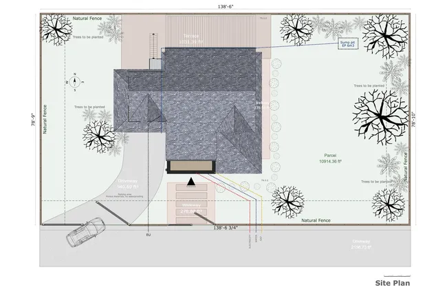
Complete the Site Plan
- Insert symbols: Add details needed for clear understanding such as vehicles, vegetation, accessibility, custom shapes, and more.
- Add annotations: Customize plans with text, lines, and arrows to represent utilities and pipes.
- Add dimensions: Place custom dimensions on your site plan and tailor how they display.
Combine Cedreo Features
Once your terrain model is set, use these features to add landscaping and generate 3D visuals that help clients understand the design.
Terrain Design
Arrange outdoor areas on the finished terrain and present a layout aligned with your clients’ expectations.
3D Furnishing
Choose from a wide range of outdoor furniture, décor, and surface coverings to help clients picture their future landscape.
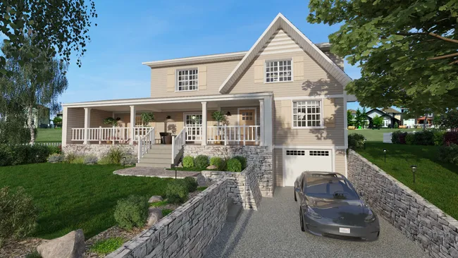
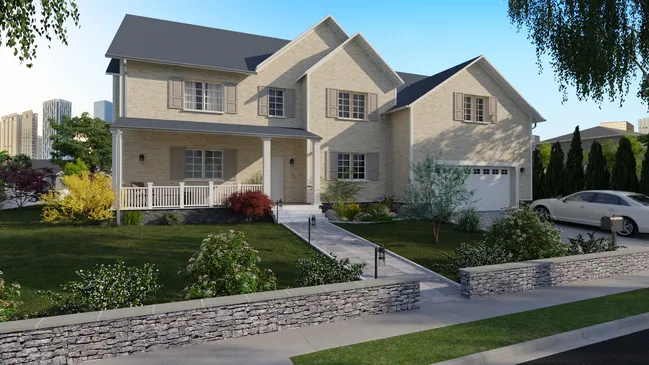
3D Renderings
Give clients confidence in their decisions with realistic 3D perspectives of site landscapes.
Create Terrain Models Like These with Cedreo Software
From flat lots to sloped sites, see examples of entire landscapes created with Cedreo’s terrain tools.
Simple Terrain Modeling
With the “spaces” tool, you can define different outdoor areas such as lawns, flower beds, and garden plots.
Sloped Terrain Modeling
Adjust terrain elevation & contour lines to get an accurate representation of your site’s topography.
Terrain Modeling with a Driveway
Draw driveways with or without curbs. Choose between straight or rounded edges and a variety of surface materials.
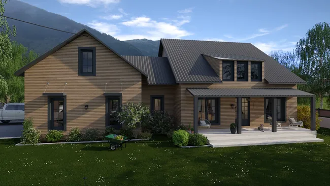
Terrain Modeling with a Deck or Patio
Draw decks easily and adapt them to the terrain by selecting the appropriate elevation and thickness. If needed, add skirting with one click.
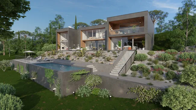
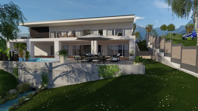
Terrain Modeling with a Pool
Create in-ground pools using spaces to display them on section plans.
Terrain Design with a Pond
Design different outdoor spaces for a variety of uses like relaxation, play areas, outdoor dining, etc.
Frequently Asked Questions
The difference lies in the condition of the ground before and after construction or landscaping work.
- Natural terrain: may include irregularities (slopes, banks, bumps, depressions) and serves as the reference for project design. Altimetric data are essential to plan earthworks (cut and fill).
- Finished terrain: results from modifications (leveling, filling, creating banks, trenches, platforms) and includes outdoor features (driveways, green spaces, pools, fences). It must meet permitting constraints, especially final elevations and access points.
With Cedreo’s 3D terrain modeling software, you can model the natural terrain, then modify it to produce the finished terrain with accurate house placement. Cedreo’s terrain tools give you full control over slopes and surfaces, and the site plan and cross-sections are automatically rendered with the same precision.
You can model a realistic site using public mapping data or a land survey. Here are 3 straightforward options:
- Use free online datasets (USGS National Map, state/county GIS portals, etc.).
- Hire a surveyor for precise topographic data.
- Order existing topographic datasets.
Then import the DWG, DXF, or PDF files into Cedreo to trace the lot and represent elevation levels to the nearest inch.
Yes. A subdivision plan sits between a site plan (internal organization) and a location plan (context), with a focus on land division and shared facilities. It includes lots, roads and access, common facilities, utilities, margins and distances, and orientation. So yes, you can create a subdivision drawing with Cedreo’s site plan and terrain tools.
House placement depends on key criteria:
- Orientation: maximize natural light and energy performance and consider sun paths and shadows.
- Local planning rules: setbacks, alignment with the road, authorized height, etc.
- Site conditions: slope, access, existing vegetation, plus project needs like garage location, patio exposure, and protected views.
A professional site plan created with Cedreo’s terrain design tools lets you simulate alternatives and adjust placement with complete control before final approval.
Modeling terrain in Cedreo is fast and simple, even without advanced skills. Follow these steps:
- Import the land registry plan: use it as a layer for lot tracing and altimetry management, or start from scratch.
- Place the house: respect local planning rules such as setback lines.
- Landscape the terrain: add driveways, fences, retaining walls, vegetation, and outdoor furniture. Use Cedreo’s terrain tools to create and modify slopes and surfaces so the environment matches reality.
- Create exterior 3D renderings: present a complete project with visuals of the client’s future garden. Adjust materials and textures to explore different scenes before they’re rendered.
Yes. Cedreo’s 3D terrain modeling tools handle sloped or irregular sites using altimetry controls such as elevation points and elevation lines. You can also manage earth retention with the Retaining Wall and Embankment tools. For driveways, choose how elevations are handled: have them follow the natural terrain or control them point by point to simulate hills and complex geometry.
Cedreo’s terrain tools let you create a believable landscape quickly, so clients see the house, grades, and outdoor features as one rendered environment. You can shape slopes, adjust volumes, and dial in surface textures to the level of detail a professional presentation demands.
Many users experiment with several design options in one session, then export visuals and files that fit right into your existing workflow. The result? Clear decisions, fewer meetings, and a stronger sense of unity between the building and site.
It’s easy to use.
But you can always count on Cedreo support.
For an even faster start, access tutorials and help articles.
Get tips to do more, faster.

“Precise terrain modeling helps us avoid unpleasant surprises during technical visits.”