Every successful construction project begins with thorough site analysis and development planning. Whether you’re a home builder, contractor, or landscape designer, understanding the site planning process is essential for any land development project.
But are you maximizing your site’s potential? Are you meeting all the requirements for efficient site development? Read on to learn everything you need to know about creating effective site plans and managing the planning process, including:
- Understanding the Site Planning Process
- Essential Site Analysis Steps
- Creating Complete Site Plans
- Key Development Considerations
What is Site Planning?
Site planning is a preliminary step for any construction project. A site plan will help you analyze existing and proposed conditions to organize all aspects of development. From establishing property lines and access points to planning drainage patterns and building placement, this crucial phase maximizes a site’s potential while ensuring compliance with zoning regulations and building codes.
A complete site plan serves a different purpose than a floor plan. Whether you’re building new homes, planning renovations, or designing landscapes, site plans give you the big picture: they show how structures (both existing and proposed) interact with the land’s natural features, like topography, drainage patterns, and tree cover. This comprehensive view ensures your project works with the entire property, not just individual buildings.
Site planning typically occurs early in the development process because it thoroughly explains what the entire project requires, from initial site analysis to final construction.
Essential Site Analysis Steps
A comprehensive site analysis serves multiple purposes in the building project. While site plans don’t specify exact building materials or detailed designs, they establish where buildings will be positioned, define property lines, and show how the development integrates with the built environment. This makes them essential for zoning permit applications and project feasibility studies.
The site analysis provides invaluable insights when presenting development ideas to clients or coordinating with your construction team. It helps stakeholders understand how the project will utilize the existing land and integrate with surrounding properties while adhering to construction limits.
Remember that this is one crucial component of a larger planning process. Your site plan works alongside other essential documents throughout a land development project.
Site Planning Phases
Here are all the components of a complete site plan for your project:
Project Identification
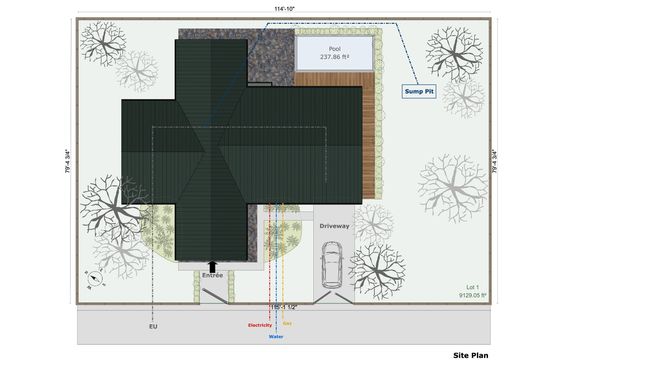
Begin your site planning process by documenting fundamental project identification details. Every complete site plan must start with clear documentation of the project title, development type, and comprehensive property information. Include the exact property address and parcel details, marking all scale references and directional indicators (like the north point). Document key stakeholders, including client information and contractor details, as these will be essential for project coordination.
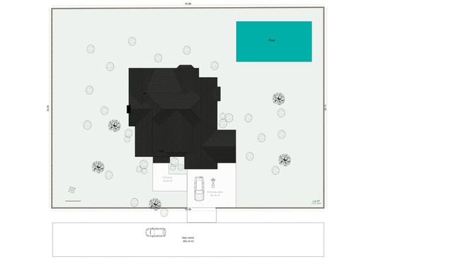
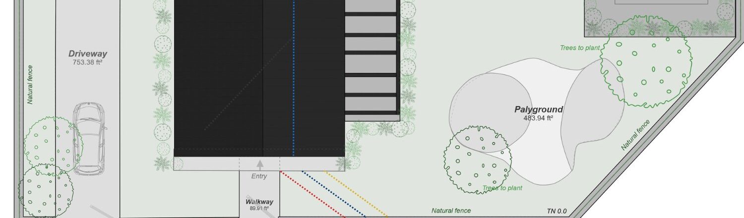
Site Boundaries and Structures
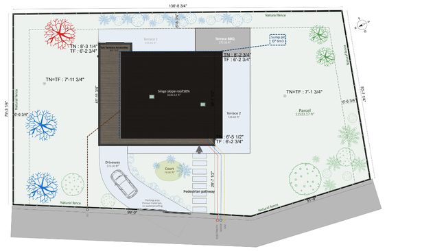
When mapping site boundaries and structures, precision is crucial. Carefully delineate property lines and required setbacks, as these form the legal framework for your development project. Document all existing buildings and structures on the site, along with areas designated for new construction. If your project involves demolition, clearly indicate which structures will be removed. Include detailed building footprints and dimensions to ensure accurate spatial planning.
Landscape and Natural Features
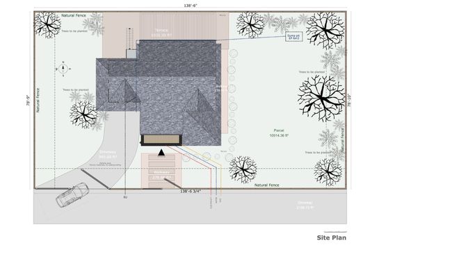
Natural features play a vital role in site development. Survey and document all existing trees and vegetation that should be preserved, marking areas designated for new landscaping. Pay special attention to water features and existing drainage patterns, as these will significantly impact your development decisions. Record terrain contours and grade changes, noting any special soil conditions that might affect construction.
Access and Circulation
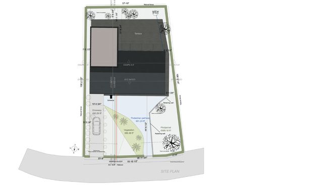
Access and circulation planning ensures smooth movement throughout the site. Design and document all entry points, including driveways and walkways. Consider both immediate and long-term parking requirements in your plan. During the construction phase, you’ll need marked access routes for construction vehicles while maintaining emergency vehicle access throughout the project.
Infrastructure and Utilities
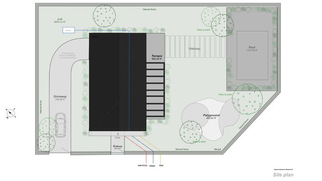
Infrastructure and utility planning requires careful coordination. Map out all utility connections, including water, electrical, and gas service points. Plan sewer and drainage systems that integrate with existing infrastructure. Consider future needs when planning external lighting, ensuring adequate illumination for safety and functionality.
Regulatory Compliance
Finally, address all regulatory compliance requirements. Research and document applicable zoning requirements and required setbacks or buffers. Note any environmental protection areas that must be preserved. If your site has historical significance, include preservation considerations. Most importantly, identify all necessary permits required for project completion.
This comprehensive approach to site planning ensures you’ve covered all essential elements while meeting the needs of your project stakeholders and local authorities.
Critical Site Planning Considerations
Before beginning any land development project, thoroughly understanding these crucial factors will ensure your site planning process addresses all potential challenges and opportunities.
Natural Factors and Environmental Impact
Construction projects must work in harmony with the natural environment. Consider:
- Local wildlife habitats and migration patterns
- Natural vegetation and tree cover preservation
- Climatic factors affecting construction
- Seasonal changes and weather patterns
- Sustainable practices for long-term environmental protection
- Green spaces and natural beauty preservation
Soil Conditions and Geology
Understanding soil conditions is essential for civil engineering decisions:
- Rocky soil identification and management
- Subsurface stability assessment
- Foundation requirements and limitations
- Soil erosion potential
- Drainage capacity
- Construction limits based on soil type
Topographic Features and Site Analysis
Existing topographical features significantly influence your site development:
- Natural slopes and gradients
- Drainage patterns and water flow
- Landscape architecture opportunities
- Potential site constraints
- Required terrain modifications
- Impact on construction costs
Water Management and Drainage
Consider both visible and hidden water features:
- Surface water features and management
- Subsurface water conditions
- Seasonal water flow patterns
- Stormwater management requirements
- Flood prevention measures
- Water table implications for development
Existing Structures and Proposed Buildings
Conduct a thorough analysis of existing and proposed conditions:
- Current building locations and conditions
- Structures marked for removal
- Integration of proposed buildings
- Existing land use patterns
- Property lines and setbacks
- Building codes and zoning regulations
Urban Planning and Community Impact
Consider how your development project affects the built environment:
- Cultural factors and historical significance
- Community members’ needs and concerns
- Traffic flow implications
- Access points for various users
- Bike lanes and pedestrian paths
- Integration with surrounding developments
Feasibility and Compliance
Ensure your site development meets all requirements:
- Zoning laws and regulations
- Construction limits and restrictions
- Required feasibility studies
- Planning department requirements
- Urban planning guidelines
- Essential permits and approvals
Simplify Site Planning with Cedreo
Modern construction projects need efficient solutions. Cedreo simplifies the site planning process with features specifically designed for construction professionals:
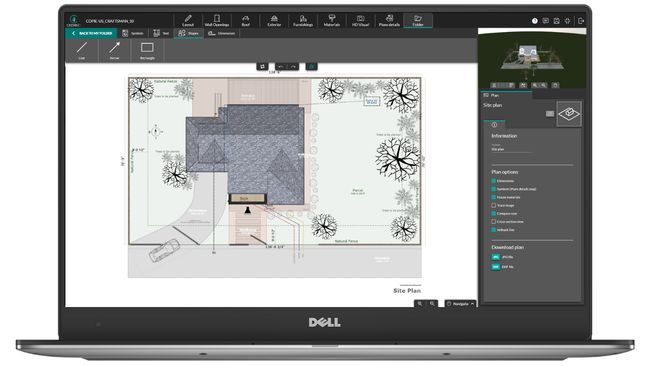
Terrain modeling: Create accurate site plans in under 20 minutes with simultaneous 2D and 3D viewing. Import existing surveys and easily manage elevation points, slopes, terrain modeling, retaining walls, and property lines.
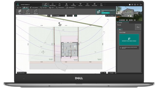
All-in-one design tool: Generate both site plans and floor plans in one unified platform. The software includes automatic features for landscape architecture elements, saving valuable time during the planning phase.
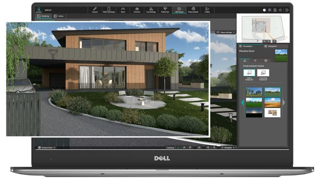
Professional presentations: Create compelling client presentations with photorealistic 3D renderings. Show clients exactly how their development project will look with accurate visualizations of buildings, landscape design, and terrain.
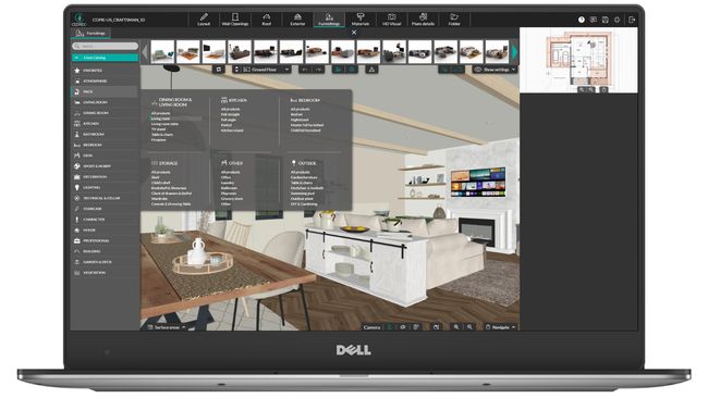
Extensive resource library: Access thousands of materials, textures, and 3D objects to bring your plans to life. Every element you need, from outdoor amenities to natural vegetation, is readily available.
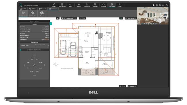
Time-saving features: Generate instant area calculations, export plans to scale, and share projects seamlessly with team members. Make real-time adjustments during client meetings and quickly update all project documentation.
Take Your Site Planning to the Next Level
Effective site planning is crucial for successful construction and landscape projects. With the right tools, you can streamline your planning process while creating more impressive presentations for your clients. Cedreo helps you:
- Reduce planning time from days to hours
- Create more professional presentations
- Win more projects with compelling visualizations
- Improve collaboration with team members and clients
- Deliver better results for every project
Ready to transform your site planning process? Try Cedreo for free today and experience how modern tools can streamline land development projects while delivering superior results.