Obtaining the proper permits is a critical step in any construction project, whether building a new house, remodeling an existing property, or adding new structures such as a garage, fence, or swimming pool. One of the most important documents local building authorities require is the site plan.
This comprehensive map of your property ensures your proposed construction or renovation project meets local zoning codes, building codes, and other necessary regulations. But what needs to be included in a site plan for a permit? This article will walk you through everything you need to know.
What Is a Site Plan for a Permit?
A site plan for a permit is a detailed drawing showing your property’s layout and how the proposed construction will be situated within that space. Local building authorities use these plans to verify that your construction project will comply with zoning laws, setback requirements, utility access, and other regulations.
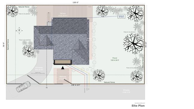
The site plan showcases your proposed building or modifications. It includes critical information such as property lines, lot dimensions, roofline, parcel ID, building setback distance, measurements between major features, north arrow, scale, driveway, fence, sidewalks, trees, swimming pool, lawn, parking spaces, additional new structures, shrubs, topographic contour lines, and well & septic systems to ensure compliance with all requirements.
Types of Projects Requiring a Site Plan for a Permit
Whether undertaking residential projects or changing an existing structure, complete site plans are often required to obtain a permit. Some common projects that require a site plan include:
- New Construction: A site plan is essential when building a new house to show how the structure will fit within the lot and meet setback requirements.
- Additions or Remodels: If you are adding a room, expanding a home, or building a new garage, you must submit a site plan to demonstrate how the expansion fits into the overall layout.
- Fences and Walls: A simple fence or wall around the entire lot may be necessary to meet local setback standards and not infringe on easements or property boundaries.
- Swimming Pools or Decks: Installing a swimming pool or deck requires a site plan to ensure it is located safely and according to local building codes.
- Landscaping Features: A site plan is often necessary for major landscaping projects that alter the property’s terrain or include elements like new structures, large trees, or garden beds.

Understanding when a site plan is needed will help you comply with local zoning codes and expedite the permit application process.
Essential Information to Include in Your Site Plan for a Permit
A comprehensive and accurate site plan includes various details that local authorities require for review. Here are the key elements that should be present in your site plan:
- Property Lines and Boundaries: Clearly define the property boundaries of the lot, including all corners, sides, and boundaries, to establish the size and limits of the project.
- Lot Dimensions: Include lot dimensions (length and width) and the total area of the site. This helps local authorities assess whether the site is large enough for the proposed structure.
- Primary Structure: Show the location of the primary structure on the property, including the footprint of the house or main building.
- Setback Requirements: Indicate the setback distances, which are the required spaces between the proposed building and property boundaries or neighboring structures. These vary based on zoning laws.
- North Arrow and Scale: Include a north arrow to indicate orientation and a scale to accurately represent the size of the project.
- Driveways, Sidewalks, and Roads: Mark all existing driveways and proposed sidewalks or roads that will be part of the project.
- Parking Spaces: Show any new or existing parking spaces that will be part of the construction project.
- Swimming Pools and New Structures: Include any proposed new structures, such as swimming pools, outdoor structures, or storage sheds.
- Vegetation and Landscaping: Include trees, shrubs, and garden features that may affect the development, and note their location on the property.
- Topographic Contour Lines: For sites with significant elevation changes, include contour lines to indicate the property’s slopes and elevation changes.
- Septic and Utility Systems: Mark the location of existing or proposed septic systems, sewage, and utility lines. This is especially important for areas without city sewer services.
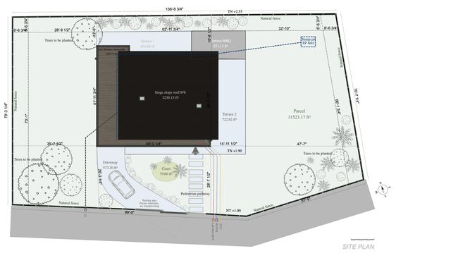
These are just a few essential components to include in your site plan for permit approval. Consult your local zoning office or building department to confirm any additional information about your location or project.
Site Plan Requirements Vary by Location
One of the most important things to remember when preparing a site plan is that the requirements vary greatly from city to city or even within different neighborhoods. What is needed in one area may not be necessary in another. For instance:
- Utility Information: Some cities may require you to show detailed utility info on the site plan, including water lines, gas lines, and electrical service points. Others may not require this level of detail.
- Easement Information: If your property has easements—such as access rights for a neighbor or utility companies—these must be shown on the site plan.
- Wetlands and Protected Areas: In certain areas, if the property contains wetlands, flood zones, or other protected areas, these must be noted as part of the site plan.
- Additional Local Codes: Different local building and development codes may require unique details, such as showing fire hydrants or the exact location of power lines and telephone poles.
By understanding these local differences, you’ll be able to provide all the necessary information and avoid delays in the permitting process.
How to Create a Site Plan for a Building Permit
To create a site plan for a building permit, you must gather accurate information about your property and proposed project. Start by measuring the lot dimensions, marking property lines, and including all existing structures. Ensure that your drawing includes all required elements—like setbacks, driveways, and landscape features—and that it’s drawn to scale.
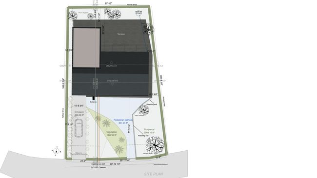
While a basic site plan can be created by hand or with software, specialized tools like Cedreo can make the process much faster and more accurate. Cedreo offers terrain modeling software that helps you visualize the land’s natural features, and its site plan software lets you add all required elements efficiently.
Check out our complete guide here.
Why Use Cedreo for Site Plans?
When preparing a site plan for a permit, using the right tools can make a significant difference. Cedreo offers a powerful solution for creating non-certified site plans for permits with precision and ease. Some of the key features include:
- Terrain Modeling: Easily integrate topographic information, such as contour lines and elevation changes, directly into your site plan, giving you a more comprehensive view of the land.

- Accurate Site Plans: Cedreo helps you design accurate site plans by offering easy-to-use templates and tools for adding structures, parking spaces, landscaping, and more.
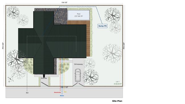
- 3D Site Plans: Present your projects to clients in an immersive way with 3D site plans and exterior renderings. This can help clients better visualize their future home or improvements.
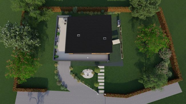
- Efficient Project Presentations: Cedreo makes it easy to generate high-quality presentation documents to share with clients or permit authorities.
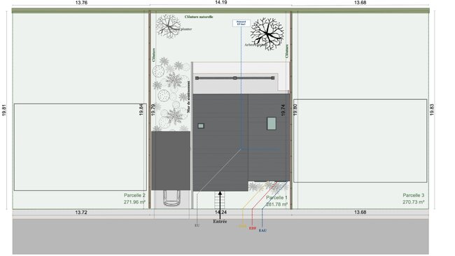
For projects requiring certified site plans, consulting with a local engineer or surveyor is essential to get the plan stamped and approved.
Master Site Plans for Ease of Permitting
A site plan for a permit is an essential part of the permitting process, ensuring that your construction project complies with local regulations and codes. By including all the required information—property lines, setback requirements, and landscape features—you’ll be well on your way to obtaining the necessary permits for your residential building project.
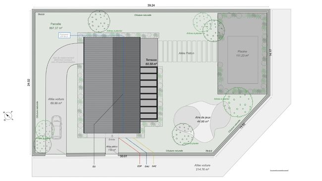
With the right tools, like Cedreo’s site plan software, you can create and present these plans to clients. Remember that local regulations vary, so always check with the local zoning office or permit department to ensure your site plan includes everything needed for approval.


