A residential site plan is a critical first step at the outset of a new build or remodeling project. These plans bridge the gap between existing conditions and future vision, playing an essential role in getting approvals from building authorities and winning new business.
What Is a Residential Site Plan?
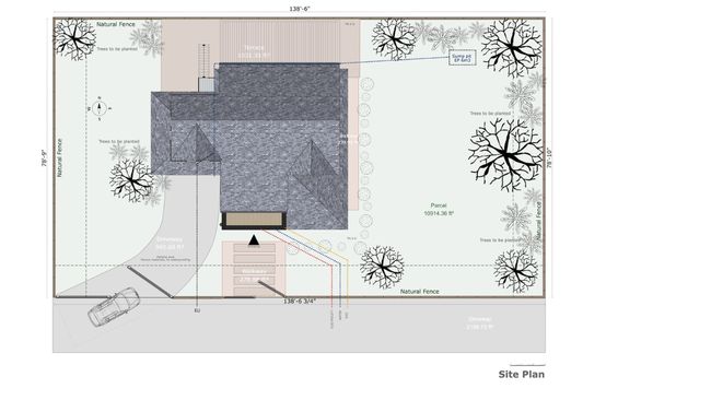
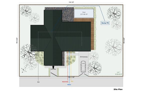
A residential site plan is a scale drawing that maps out all major components within a property’s boundaries, developed using county parcel maps, plot plans, and often satellite imagery or GIS information from public sources. A detailed site plan begins with a thorough site visit and gathering existing documentation.
For residential projects, these plans show the residence, utility hookups, site topography, and additional structures like swimming pools, patios, or pathways. These comprehensive drawings are both a regulatory requirement for building permits and a powerful visualization tool for your clients.
When Are Residential Site Plans Required?
Site plans are an obvious must for commercial properties. But it’s also important to understand when you need a site plan for residential construction or renovation projects. Here’s a breakdown of residential projects that typically require these plans:
New Residential Construction
Site plans are imperative for new home construction. Every new residential build requires a detailed site plan based on public information sources and the preliminary site visit.
This doc must show:
- Property boundaries and setbacks
- House placement and orientation
- Driveway location and parking areas
- Utility connections
- Grading and drainage plans
The exact specifications can vary depending on the dwelling type, which may be:
- Single-family homes
- Duplexes and triplexes
- Accessory Dwelling Units (ADUs)
- Multi-unit residential developments
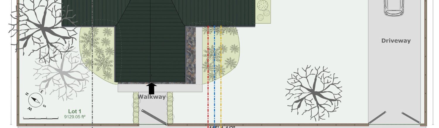
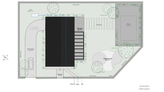
For new construction, your site plan documentation must include comprehensive details beyond basic measurements. Start with all proposed structures and their precise dimensions, incorporating building height calculations and finished floor elevations demonstrating compliance with local codes.
Property boundaries, setbacks, house placement, and orientation must be marked. Include driveway location and parking areas, ensuring adequate space for vehicles. Grading and drainage plans, utility connections, and easements need careful documentation.
The site plan should showcase existing site features and topography, distance to adjacent structures, fire access routes, and erosion control measures. Stormwater management features should be thoroughly outlined, along with any required landscape elements.
Home Additions & Renovations
Any significant change to your home’s footprint requires a site plan. Common projects include:
- Room additions
- Second story additions
- Garage conversions
- Extended living spaces
For these projects, site plans must show existing structures and proposed changes, helping building authorities understand how modifications impact the overall property layout.
When documenting a renovation or addition project, your site plan must tell the complete story of existing conditions and proposed changes. Begin by accurately representing the current structure’s footprint, then clearly indicate the location and dimensions of proposed additions. Include updated setback measurements from all property lines, showing compliance with current codes.
Detail how the modifications affect drainage patterns across the property and specify any necessary utility modifications. Construction access routes and material staging areas must be identified to minimize site disruption. If there are protected trees nearby, include designated protection zones. Finally, update lot coverage calculations to ensure the project meets local development standards.
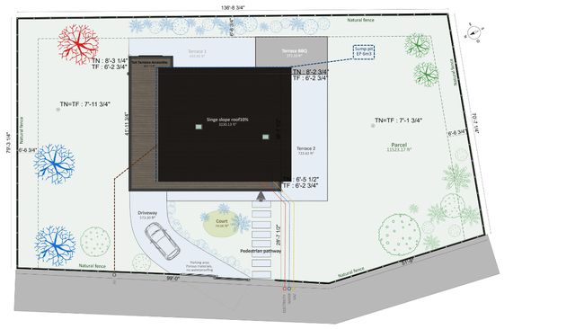
Outdoor Living Projects
Modern homeowners increasingly invest in outdoor living spaces, many of which require detailed site plans:
- Decks and porches (especially those over 30″ in height)
- Swimming pools and spas
- Outdoor kitchens and entertainment areas
- Large patios and covered structures
These projects often involve complex grading, drainage, and utility considerations that must be documented in the site plan.
For outdoor living projects, your site plan must address both aesthetic and technical requirements. Begin with precise structure dimensions and setback measurements, ensuring all elements comply with local zoning codes. Detail the locations of any equipment, such as pool pumps or outdoor kitchen utilities, along with planned utility runs for water, gas, and electrical connections.
Show how the project will modify existing drainage patterns and what measures will be taken to manage runoff. Include detailed specifications for safety barriers, particularly around pools or elevated structures. Lighting plans should be incorporated to address both functionality and potential neighbor impact. Access paths must be marked, with attention to emergency access requirements. Include material specifications that meet local building codes.
Accessory Structures
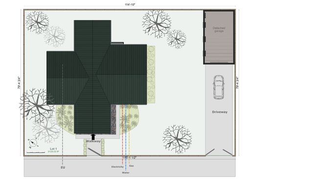
Any substantial separate structure typically requires a site plan, including:
- Detached garages
- Storage buildings over 200 square feet
- Workshops
- Pool houses
- Guest houses
The site plan must show how these structures relate to the main residence and property lines, ensuring compliance with local zoning requirements.
When planning accessory structures, your site plan must address several key aspects of the project. Start with the structure’s exact dimensions and its distance from the main residence, ensuring compliance with fire separation requirements.
Document setbacks from all property lines and demonstrate how the structure fits within lot coverage limitations. Detail any needed utility connections, including electrical, plumbing, or HVAC systems. Show access paths and how they integrate with existing site circulation. Height calculations should be documented, along with any grading changes needed for proper drainage. Include updated lot coverage calculations to ensure compliance with local zoning requirements.
Landscape & Hardscape Projects
Major landscape modifications often require site plans, particularly when they involve:
- Significant grade changes
- Retaining walls
- Large-scale hardscaping
- Complex drainage systems
- Major tree removal or planting
For landscape and hardscape projects, your site plan must provide a comprehensive view of existing conditions and proposed changes. Document current and proposed grades, showing how changes will affect drainage patterns across the property. Include detailed soil erosion control measures that will be implemented during construction.
Specify plant locations with species information and provide a complete irrigation system layout if applicable. Lighting plans should be included, showing both fixture locations and illumination patterns. Detail all hardscape materials and their installation specifications, particularly for permeable surfaces. Show construction access routes and tree protection measures for any existing vegetation. Finally, comprehensive stormwater management details should be included to demonstrate how the modified landscape will handle water flow.
Types of Residential Site Plans
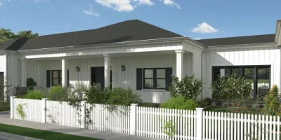
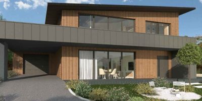
Residential site plans may come in 2D and/or 3D formats, each serving distinct purposes in the planning and presentation process. Traditional 2D plans provide clear overhead views with precise measurements and annotations, which are essential for permit applications and contractor guidance. These technical drawings typically include property boundaries, setbacks, building footprints, and utility locations. Meanwhile, 3D site plans transform these basic layouts into powerful visualization tools. Cedreo’s 3D capabilities allow you to show clients exactly how their finished project will look, with realistic material textures, accurate shadow studies, seasonal lighting conditions, and even landscape growth projections.
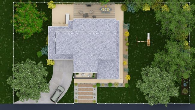
This dual approach ensures you have the technical precision for approval processes and the visual impact required to win clients. For complex residential projects, combining 2D and 3D views helps all stakeholders—from building officials to homeowners—fully understand the scope and impact of the proposed work.
Creating Professional Site Plans with Cedreo
Cedreo provides a comprehensive solution for creating detailed, professional site plans that meet regulatory requirements and client expectations. Our software offers:
Advanced Terrain Modeling
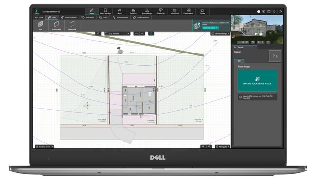
- Import existing plot plans for accurate base measurements
- Model natural and finished terrain in under 20 minutes
- Add elevation points for precise grading visualization
- Automatic calculation of cut and fill requirements
Integrated Design Features
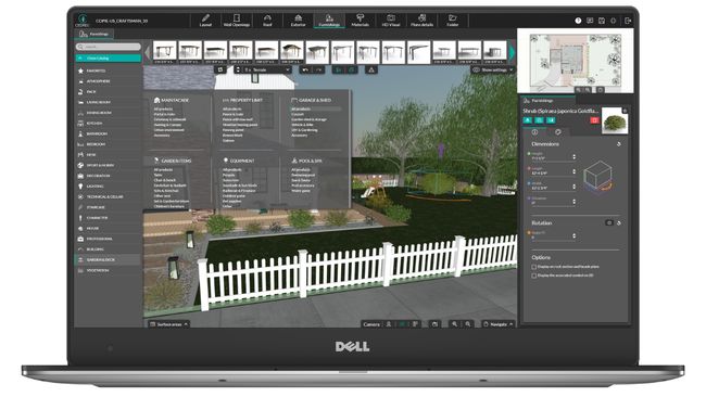
- Simultaneous 2D and 3D visualization
- Extensive library of landscape elements and materials
- Automatic dimension calculations
- Real-time surface area calculations
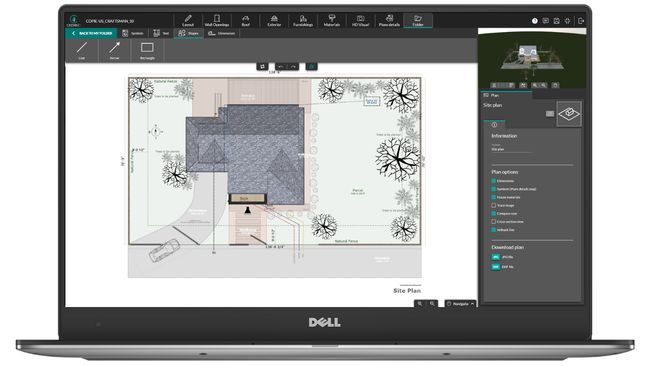
Presenting Your Site Plans to Clients
With Cedreo, you can create compelling presentations that help close deals:
- Generate photorealistic 3D renderings in minutes
- Create custom presentation documents with your branding
- Include multiple views and angles
- Add detailed material specifications
- Provide accurate cost estimates
Our presentation tools help you communicate your vision clearly and professionally, increasing client confidence and project approval rates. Get a free trial of Cedreo started by clicking here!
Create Great Site Plans for Residential Construction
Detailed site plans go beyond basic drawings. They’re powerful visualization tools. Residential site plans blend precision documentation and immersive visualization, transforming how you plan, permit, and present residential projects.