An interior is only half the battle when tackling a new build, renovation, or additional structure project.
Exterior elements, like the site elevation, easements, property lines, slopes, terrain, and environmental features, are just as (if not more) critical.
After all, you can’t have a new structure without land to put it on.
For home builders, contractors, and landscape designers, site plan drawings are an indispensable tool in the construction process.
A site plan is like a detailed map serving as a critical bridge between conceptual ideas and physical reality. It helps ensure projects are executed efficiently and in compliance with local regulations.
By emphasizing the importance of site plans in successful project execution, this guide will explore the fundamentals of site plan drawing, their types, the creation process, and best practices for implementation.
Let’s get drawing!
Key Takeaways
- Plan for precision and detail: Include all necessary components in your site plan, such as property lines, existing and proposed structures, and utility connections. This forces accuracy and helps prevent costly mistakes during construction.
- Ensure regulatory compliance: Always verify that your site plan complies with local zoning laws and building codes to avoid permit issues and project delays. Use your site plan to demonstrate compliance and streamline the permitting process.
- Choose the right software: Select site plan software that aligns with your project’s complexity and your team’s technical expertise. Tools like Cedreo offer user-friendly interfaces for rapid design and collaboration.
- Understand different site plan types: Recognize the unique features and applications of residential, commercial, and landscape site plans to help you plan accordingly.
What is a Site Plan Drawing?
A site plan in construction is a detailed architectural map that provides a comprehensive overview of a property’s layout and intended land use.
It is an essential tool in the construction process, serving as a visual representation of how proposed structures, landscaping, and infrastructure will integrate into the building site.
Unlike a floor plan, which focuses on the interior layout of a building, a site plan is an aerial view that includes all elements within the property boundaries.
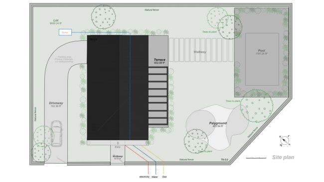
Key Components of a Site Plan
A comprehensive site plan typically includes the following components.
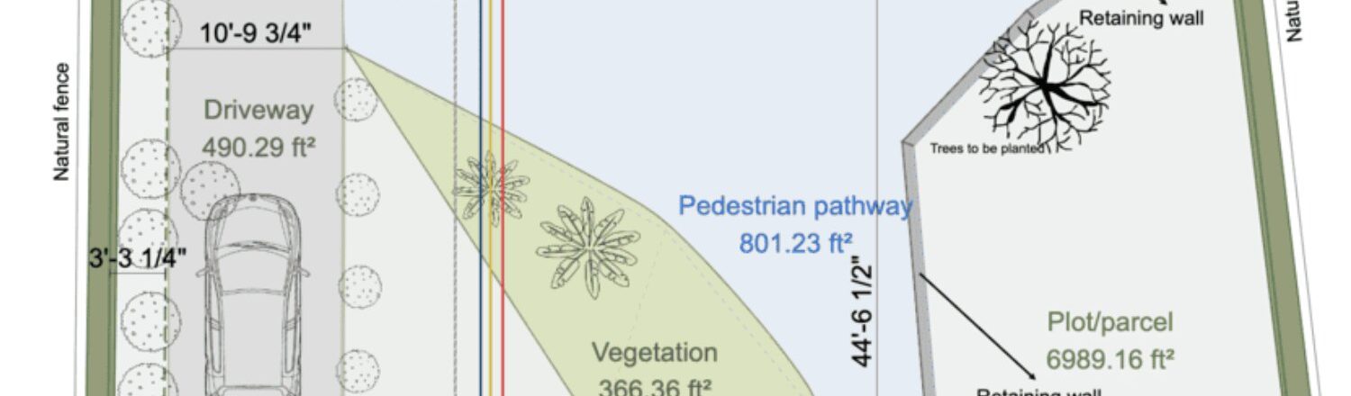
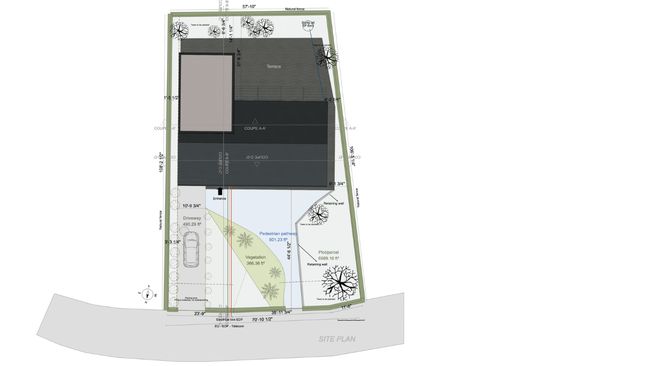
Property Lines
Property lines are the clearly marked boundaries that define the construction limits and distinguish the property from neighboring lands. These lines are crucial for establishing the size and shape of the property, ensuring any proposed structures comply with zoning regulations and do not infringe on adjacent properties.
Property lines typically include precise measurements like dimensions, a north arrow, and a scale indicator to help local authorities assess whether the site is large enough for the proposed structure and to verify compliance with setback requirements.
Existing and Proposed Structures
Existing structures include all current buildings on the property, such as houses, garages, sheds, and other outdoor features like patios and decks.
Proposed structures detail any new buildings or improvements planned for the site, such as additional rooms, new garages, or outdoor living spaces. This information makes sure the proposed changes align with local building codes and zoning laws.
Landscape Features
Landscape features identify natural elements like trees, vegetation zones, and hardscaped areas. These details are crucial for integrating the natural environment into the design, assuring the project respects existing environmental conditions and complies with local regulations regarding tree preservation or environmental protection.
Landscaping elements and terrain design also include garden elements, water features, and other outdoor design elements that contribute to the aesthetic and functional appeal of the property.
Utility Connections
Utility connections include utility lines, power lines, drainage facilities, and sanitary sewer/water lines. You need these elements so the site has the necessary infrastructure to support the proposed structures and comply with health and safety regulations. Utility connections must be accurately mapped to avoid conflicts with existing infrastructure and ensure all necessary services are accessible.
Traffic Flow and Parking Spaces
Traffic flow and parking spaces are mapped out to optimize access and usability in a development project. This includes driveways, parking spaces, and pathways that facilitate movement around the property. Proper planning of these elements is crucial for maintaining compliance with local codes regarding accessibility and parking requirements.
Easements
Easements are features shared with others for specific purposes, such as utility lines or pathways that cross the property. These must be clearly documented on the site plan. Doing so clearly shows that any proposed development respects existing easements and does not infringe on neighboring properties or utility access rights.
Topography and Gradients
Topography and gradients detail the site’s elevation, slopes, and drainage patterns. This information is vital for assessing how the site will handle water runoff, protecting the structural integrity of structures, and planning for any necessary grading or drainage solutions.
By including these elements, a site plan provides a complete picture of the property and its surroundings, facilitating effective project planning and compliance with local regulations.
Why is a Site Plan Drawing Important?
Site plan drawings are crucial for the success of any construction project, serving as a vital link between project conception and execution.
One of their most significant roles is facilitating the acquisition of necessary building permits. Local building authorities rely on site plans to verify that a proposed construction or renovation project complies with zoning laws, building codes, and other regulatory requirements.
Let’s take a look at some other reasons these documents matter so much.
Building Permits
Obtaining a site plan for a building permit is a critical step in any construction project. A comprehensive site plan is essential for this process, as it provides local authorities with the necessary information to assess whether a project complies with local regulations.
By including details such as property lines, setbacks, and utility connections, site plans help authorities determine if a project meets all requirements for approval.
Zoning Laws
Zoning laws vary significantly from one location to another and play a crucial role in determining how land can be used. These laws govern aspects such as the type of structures allowed, their size, and placement on the property.
For instance, zoning ordinances dictate setback requirements, which are the distances between structures and property lines. Accurately representing these setbacks on a site plan is essential to comply with zoning regulations and avoid permit rejection.
Building Codes
Building codes focus primarily on safety and structural integrity, covering elements like fire resistance, accessibility, and energy efficiency. These codes are designed to ensure buildings are constructed to withstand various environmental conditions and provide a safe environment for occupants.
A well-drafted site plan must account for these codes so the project meets all necessary safety standards and complies with local regulations.
Regulatory Compliance
Regulatory compliance is a key aspect of site planning. Site plans must demonstrate that a project aligns with all relevant local regulations, including zoning laws and building codes. This keeps the project safe and legal, avoiding potential legal issues or project delays.
Beyond zoning and building codes, site plans may need to address other local regulations, such as environmental protections or easements. In areas with protected natural features, like wetlands or flood zones, site plans must identify these areas to ensure the project does not infringe on them. Similarly, easements—shared access rights for utilities or neighboring properties—must be clearly marked to prevent conflicts.
Benefits of Compliance
Compliance with local regulations avoids legal issues and enhances the project’s overall quality and safety. A site plan that meets all regulatory requirements helps streamline the construction process, reducing the risk of costly rework or project delays.
It also provides stakeholders with a clear understanding of the project’s scope and potential impacts, fostering better collaboration and decision-making throughout the development process.
The Most Common Types of Site Plans
Site plans are categorized based on their application and the type of project they serve. The three main types are residential, commercial, and landscape site plans, each with unique features and uses.
Residential Site Plans
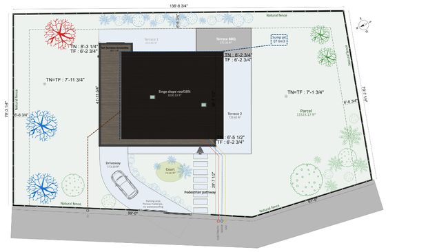
Residential site plans are detailed drawings used for new homes or remodeling projects. These plans map out major components within a property’s boundaries, including the residence itself, utility hookups, site topography, and any outdoor features like pools, patios, or pathways.
Residential site plans serve as a step-by-step guide for improving existing residences, such as adding a garage or building an extension.
For new construction projects, residential site plans typically need to be more detailed, as they are starting from scratch. This includes precise information about the property’s dimensions, zoning compliance, and the placement of the new structure within the lot.
Additionally, these plans often include details about accessory units such as detached garages, pool houses, sheds, and storage structures. These accessory units can add significant value and functionality to a property, but they must be carefully integrated into the overall site plan for compliance with local building codes and zoning regulations.
Examples of residential site plan projects include:
- New home construction: A site plan is essential for building a new house, as it outlines the placement of the home on the property and its relationship to existing features like trees and utility lines.
- Home renovations: For projects like adding a room, expanding a home, or building a new garage, a site plan helps ensure that the proposed changes comply with local building codes and zoning regulations.
- Accessory units: Installing or modifying accessory structures like pool houses, gazebos, or standalone workshops requires a site plan to ensure these additions are safely located and comply with local regulations.
Commercial Site Plans
Commercial site plans are drawings that detail the intended use and development of a commercial property. These plans are crucial for securing permits and ensuring compliance with local zoning laws and building codes. They include features such as property lines, primary structures, parking spaces, and landscaping elements like trees and shrubs.
Examples of commercial site plans include:
- Office building development: A commercial site plan is necessary for constructing or renovating office buildings, as it outlines parking layouts, access routes, and the placement of signage.
- Retail store expansion: For expanding a retail store, a site plan helps in planning additional parking spaces, outdoor displays, and ensuring compliance with ADA accessibility standards.
Landscape Site Plans
Landscape site plans focus on the aesthetic and functional aspects of a property’s outdoor spaces. These plans detail landscaping elements such as trees, gardens, swimming pools, patios, and hardscaped areas like walkways and driveways.
Examples of landscape site plan projects include:
- Garden design: A landscape site plan is used to design elaborate garden features, specifying plant selection, soil preparation, and irrigation systems.
- Outdoor living spaces: For creating outdoor living areas, such as patios or decks, a site plan helps in integrating these features with existing landscaping and ensuring that they complement the property’s natural environment.
How to Get a Site Plan
Obtaining a site plan of a property is a crucial step in any construction or renovation project. There are several ways to acquire a site plan, depending on whether you need a new plan or can use an existing one.
For New Site Plan
If you need a new site plan, here are some options:
Consider Land Surveyors
Hiring a land surveyor is a traditional method for creating a site plan. Land surveyors provide detailed information about property boundaries, topography, and existing structures. They are particularly useful for complex projects or when precise boundary information is needed.
Land surveyors ensure that the site plan is highly accurate, which is essential for compliance with local regulations. They can also provide additional details such as zoning information and easements.
But, land surveys can be expensive, often costing up to $3,000 depending on the complexity of the project. The process may also take longer due to the need for on-site measurements.
Check Out Site Plan Companies
Specialized site plan companies offer another option for creating new site plans. These companies typically use drafting software to create detailed plans based on your property’s specifications.
Pros:
- Efficiency: Site plan companies can produce plans quickly using advanced software.
- Cost-effective: Generally less expensive than hiring a land surveyor.
Cons:
- Quality variance: The quality of the plan may vary depending on the company’s expertise and software used.
Use Site Planning Software To Do It Yourself
Using site plan software to create a site plan yourself is becoming increasingly popular. Mobile apps and CAD software allow you to design and draft your site plan efficiently.
This route is:
- Cost-effective: Often less expensive than hiring professionals.
- Flexible: Allows for real-time adjustments and collaboration.
- Simple to use: Many programs offer user-friendly interfaces that simplify the process.
For An Existing Site Plan
If you already have an existing site plan, you can obtain it from several sources:
Look Into Your Local Government
Local government offices, such as the county assessor’s office or planning department, often have copies of site plans on file. These plans can be accessed for a fee and may provide the necessary information for minor projects.
Search In Courthouses and Title Agencies
The local courthouse or title agencies may also have copies of site plans as part of property title reports. These documents can include site plans as part of the legal description of the property.
Keep in mind that most governments or companies will charge a small fee for copies, but it’s usually nominal. Check your local government for processes, procedures, and costs for obtaining copies of site plan records.
Cost of a Site Plan Drawing
The cost of a site plan varies significantly depending on several factors, including the complexity of the project, the size of the property, and who creates the plan. Understanding these factors is crucial for budgeting and ensuring that your project stays on track financially.
Standard Site Plan Cost Structures
Understanding the cost structure of site plans helps construction professionals and property owners make informed decisions about their projects.
The cost of a site plan generally falls into three categories based on the project’s complexity:
- Basic residential site plans: These typically involve straightforward documentation and cost less. They are suitable for single-family homes with simple lot configurations and flat terrain.
- Intermediate site plans: These involve more detailed surveys and are used for multi-structure residential projects or light commercial developments. They require input from multiple professionals, increasing the cost.
- Complex site plans: These are the most expensive and are necessary for commercial developments or multi-unit residential projects. They involve extended property analysis, environmental studies, and complex utility planning.
Factors The Influence Site Plan Costs
In addition to project complexity (discussed above), there are other factors that play a significant role in determining the final price:
- Property size: Larger properties typically require more detailed documentation and extended survey time, increasing costs. For instance, properties over 1 acre may incur additional charges due to the need for more comprehensive surveys.
- Terrain complexity: Sites with significant elevation changes or unique topographical features require specialized expertise and additional documentation, which adds to the cost. Environmental factors such as wetlands or protected areas also necessitate detailed analysis, further increasing costs.
- Who creates the site plan: The cost of a site plan can vary based on whether it is created by a land surveyor, a site plan company, or through digital software. Land surveyors often provide the most accurate information but can be expensive, while digital solutions offer cost-effective options with the flexibility of unlimited revisions.
Why Digital Solutions Make Drawing Site Plans More Cost-Effective
Digital site planning solutions have transformed the cost structure of site plans by offering a comprehensive platform for creating and modifying plans. These platforms allow for unlimited revisions and real-time changes, making them particularly cost-effective for professionals managing multiple projects.
They eliminate the need for per-plan pricing, reducing overall project costs and enhancing collaboration with clients and stakeholders.
12 (Simple) Steps to Draw An Accurate Site Plan
Creating a site plan involves several key steps, from gathering initial data to finalizing the design. Here’s a comprehensive guide to help you through the process:
1. Obtain Property Line Information
The first step in creating a site plan is to obtain accurate information about your property lines. This can typically be found through local government records or by hiring a land surveyor.
Property line information is crucial for ensuring that your proposed structures comply with zoning regulations and do not infringe on neighboring properties.
2. Measure the Property
Measuring the property accurately is essential for creating a precise site plan. You can use tools like a tape measure or GPS devices to record the dimensions of your property. Tips for accurate measurements include:
- Use multiple reference points: Take measurements from multiple points to ensure accuracy and verify that the angles and lengths match.
- Consider hiring a professional: For complex properties or when precise measurements are critical, consider hiring a land surveyor.
3. Establish the Drawing Scale
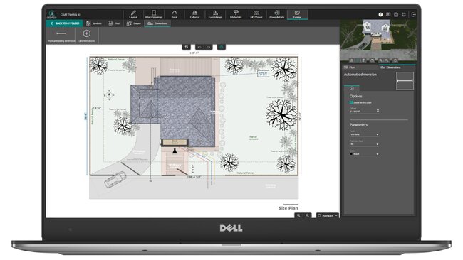
Choosing the right scale for your site plan is important to ensure that all details fit comfortably on your chosen medium, whether graph paper or digital. Common scales include 1 inch to 10 feet or 1:100 meters. This scale must allow for clear representation of all necessary elements without cluttering the plan.
4. Include North Arrow and Legend
A north arrow helps orient the site plan, while a legend explains the symbols and line types used in your drawing. These elements are crucial for clarity and understanding, especially when sharing the plan with stakeholders or local authorities.
5. Outline the Property Boundaries
Begin by drawing the property lines based on your measurements. Ensure that the angles and lengths match the data you’ve collected. Include setback lines, which are the distances between structures and property boundaries, to comply with zoning regulations.
6. Create Terrain Modeling
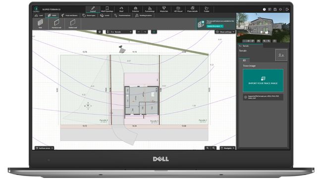
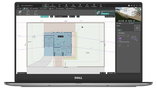
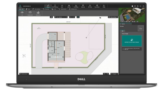
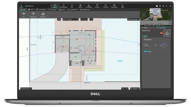
Terrain modeling involves modifying the existing landscape to fit your design needs. This can be done by importing a surveyor’s plan or land plot into your design software, tracing the plot, and then managing terrain elevation points. Include features like sloping and retaining walls if necessary to ensure your design integrates well with the natural environment.
7. Add Your Structures
Plot out the location of all existing buildings, ensuring they are to scale and properly positioned in relation to the property boundaries. This includes houses, garages, sheds, and any other structures on the property.
8. Position Utilities
If required, locate the existing utility lines for water, electricity, gas, and sewage. Accurate placement of utilities is essential for ensuring that your project does not interfere with existing infrastructure.
9. Mark Driveways and Walkways
Indicate the paths for vehicles and pedestrians, which may affect the flow and design of your land use. Properly mapping paved surfaces like driveways and walkways helps you remain compliant with accessibility standards and optimizes the usability of the property.
10. Draw Landscape Features
Include trees, gardens, and terrain changes such as slopes or water bodies. These features can impact the usability and aesthetics of the site. Use tools like Cedreo to select furnishings and materials that enhance your design.
11. Review, Annotate, and Adjust The Site Plan
Go over the plan to ensure all elements are included, accurately scaled, and clearly marked. Make adjustments as necessary for clarity and compliance.
12. Finalize and Present (Or Submit)
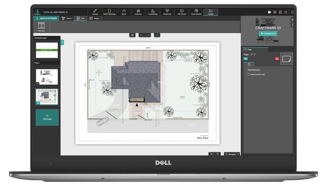
Clean up any stray marks or unclear lines. Your site plan should now be ready to share with stakeholders, serve as a blueprint for contractors, or submit for permits. Ensure the final version is clear, comprehensive, and meets all regulatory requirements.
Each step is crucial for your site plan to be accurate, comprehensive, and compliant.
Site Planning Best Practices
Creating an effective site plan requires attention to detail, clear communication, and compliance with local regulations. Here are some best practices to ensure your site plan is both functional and compliant.
Be Precise
To create a detailed site plan, precision is key. Accurate measurements are essential to avoid errors, and using tools like GPS devices or hiring a land surveyor for complex properties can help reinforce this accuracy.
Consistency in scale and orientation is also important; using a consistent scale and including a north arrow helps the site plan be easily understandable and orientable.
You also need comprehensive documentation, including all relevant details, such as property lines, existing structures, and utility connections, for a complete picture of the site.
Some key elements to include in your documentation are:
- Property lines and boundaries
- Existing structures and their dimensions
- Utility connections and easements
Communicate Effectively
Effective communication is vital among stakeholders, including architects, contractors, and clients. Engaging with all parties ensures everyone is aligned with the project’s scope and design.
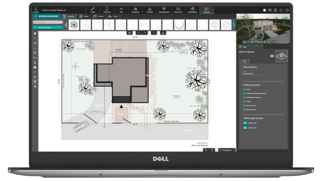
Clear visualizations, such as 3D models and detailed drawings, help stakeholders understand the project’s intent and potential impacts. Establishing clear channels for feedback and revisions makes sure that changes are incorporated efficiently.
Cloud-based construction software can keep all team members on the same page, allowing for real-time updates and collaboration. Plus, shared design platforms like Cedreo enable collaborative creation and modification of site plans, ensuring all stakeholders can access the latest version.
Remain Compliant (Always)
Compliance with local regulations is critical. Create an accurate site plan that adheres to zoning laws and building codes to avoid permit issues or project delays. Environmental considerations, such as identifying and addressing wetlands or protected areas, are also important to remain in compliance with environmental regulations.
Create an Implementation Plan
A well-organized site planning facilitates smooth project execution.
To do so, contractors and builders need clear instructions on material needs and timelines. This can be achieved by creating detailed work schedules that outline tasks and responsibilities for each day. Accurate material management using site plans reduces waste and delays.
What’s The Best Site Plan Software?
Choosing the best site plan software depends on several factors, including the type of project, the features you need, your budget, and your timeline.
Here’s an overview to help you select the best software for your needs.
Consider Your Project Type and The Features You Need
Site plan software isn’t one-size-fits-all, there are different options that suit different circumstances.
For example:
- Residential projects: For homeowners or small-scale builders, software with user-friendly interfaces and basic terrain modeling capabilities is often sufficient. Features like 2D and 3D visualization can help bring designs to life and impress clients.
- Commercial projects: Commercial projects require more advanced features, such as detailed construction documentation and robust terrain modeling. Software that can handle complex designs and provide comprehensive documentation is essential.
- Landscape projects: For landscape-focused projects, the ability to visualize and modify terrain elements is crucial. Look for software with advanced terrain modeling and visualization tools.
So consider the nature of your project before diving into a new software.
Know Your Budget
Your budget will significantly influence your software choice. Options range from affordable, cloud-based solutions to more expensive, feature-rich desktop applications.
For smaller projects or occasional use, cost-effective solutions like RoomSketcher are ideal. RoomSketcher operates on a credit-based system, which can be advantageous for those who only need to create site plans sporadically. However, this system may limit access to advanced features unless upgraded.
On the other hand, professional-grade software like AutoCAD and Chief Architect offer comprehensive features but come with a higher price tag. These tools are better suited for professionals managing complex projects who require advanced drafting capabilities and detailed construction documentation. The cost of these software options includes the initial purchase or subscription and potential training expenses due to their complexity.
Understand Your Project Timeline
If you need to complete projects quickly, look for software with rapid design capabilities and streamlined workflows.
For example, Cedreo stands out for its ability to complete designs in under two hours, making it ideal for professionals managing multiple projects with tight deadlines.
You should also look for software with collaboration tools that can enhance efficiency by allowing real-time updates and feedback among team members.
Examine the UI (User Interface) and UX (User Experience)
Consider the technical expertise of your team and how much time you can dedicate to training.
Software like Cedreo stands out for its intuitive interface, making it accessible for home builders, contractors and remodelers. This ease of use means that teams can quickly adapt to the software without needing extensive training, which is particularly beneficial for those managing multiple projects or working under tight deadlines.
On the other hand, complex software like AutoCAD requires significant training due to its advanced features and complexity. While AutoCAD is incredibly powerful and offers comprehensive drafting capabilities, its steep learning curve makes it better suited for experienced professionals who can invest time in mastering its extensive feature set.
For teams with limited technical expertise or those who cannot dedicate substantial time to training, simpler software options might be more practical.
By considering these factors, you can choose the best site plan software for your specific needs, ensuring that your projects are completed efficiently and effectively.
Common Site Plan Drawing FAQs
Have questions about site plans?
We’ve got answers.
How can I change my site plan drawing in Cedreo?
To modify a site plan in Cedreo, use the software’s intuitive editing tools. You can adjust layouts, add new elements, and update existing features easily.
Can I make a free site plan for my property?
While some software offers free trials or basic features, creating a comprehensive site plan often requires paid tools. However, you can start with free trials like Cedreo’s to explore capabilities before committing.
What happens if I start working on a project without a site plan?
Starting a project without a site plan can lead to costly delays and potential legal issues due to non-compliance with local regulations. Ensure you have a site plan before beginning construction to avoid these risks.
How long does it take to draw a site plan?
The time to draw a site plan varies based on complexity and the tools used. With software like Cedreo, you can design a complete project including a site plan in under two hours. For more complex projects, it may take longer.
Can I use a site plan for multiple projects on the same property?
While a single site plan can be adapted for different projects, it’s often better to create new plans for each project to ensure accuracy and compliance with specific project requirements.
What role does a site plan play in property valuation?
A site plan can influence property valuation by highlighting potential for development or renovations. It provides a clear visual representation of the property’s potential, which can increase its appeal and value.
Can I collaborate with others on a site plan in real-time using Cedreo?
Yes, Cedreo offers real-time collaboration tools, enabling multiple users to access a project. This enhances teamwork and ensures everyone is aligned with the project’s progress.
Create Professional Site Plan Drawings Online with Cedreo
As builders and contractors, you need quality, detailed site plans for any future projects.
Instead of relying on land surveyors, take matters into your own hands by drawing site maps for your projects in Cedreo. Start from scratch or use our site plan templates for inspiration! With our powerful tools, creating site plans has become faster and more accessible than ever.
Cedreo offers a user-friendly platform that allows professionals to design and finalize site plans in under two hours, making it an ideal solution for those managing multiple projects or working under tight deadlines.