Cross Section & Elevation Plans
When you’re planning projects for construction or renovation, cross section and elevation plans are essential. Create them fast with Cedreo.
Elevation Drawing Software to Create Elevation Views and Cross Section Plans
Cedreo makes it simple for home builders and contractors to create cross sections and elevation drawings. Our cloud‑based solution automatically generates these views from your house drawing or floor plan, without needing to download software to your computer. Prepare complete project presentations faster with precise, professional technical documents.
Clear Communication
Help clients understand the project at a glance with clear section and elevation views
Essential Aesthetic Details
Specify materials, colors, openings, and roof elements to validate the project’s aesthetic fit with its surroundings.
Essential Technical Info
Add dimensions and annotations so all trades involved can understand every detail of the plans.
Intuitive Cross Section & Elevation Plan Maker
- Generate house section plans: Drag the section cut line across your plan, choose its orientation, rotate to an exact angle, and preview changes instantly before you click confirm.
- Generate elevation plans: Cedreo automatically detects elevations. Select the elevation view, customize the details, and instantly see the result.
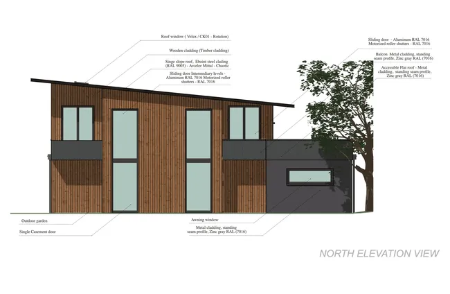
Elevation & Section Plans as Detailed as You Need
- Add precise dimensions: Place free dimensions or use smart magnetism for precise elevation dimensions.
- Visualize terrain modeling: Display natural terrain and finished terrain, terrain contours, and elevation references directly on your section plan.
- Annotate your plans: Add clear annotations and arrows, and include a legend when helpful.
- Show exterior elements and finishes: Add landscape items (trees, fences), chimneys, and light fixtures. You can also add symbols.
- Create multiple versions: For the same cross section plan or elevation plan, generate versions for different uses such as client review, interior design, or team coordination.
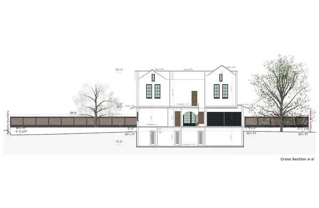
Accurate Plans that Are Always Up to Date
- Download plans to scale: Choose format, orientation, and the scale that fits your document. Save, export, and print in JPG or PDF.
- Set print parameters: Adjust margins and select print quality (72 or 300 dpi).
- Rely on automatic updates: Any change to the project keeps every elevation drawing and section plan in sync, even inside presentation documents.
Explore all Floor Plan Software Features
With these advanced features, you can design all types of houses and additions.
Wall Layout & Openings
Draw walls and partitions, place doors and windows, and define the building structure.
Learn more about walls & openings2D Floor Plans
Get a scaled 2D floor plan with notes, symbols, legend, and dimensions.
Learn more about 2D floor plansRoofs
Create the roof and valleys automatically, insert dormers and gables, and choose the finish and pitch.
Learn more about roofsSurface Area Tables
Automatically generate tables for livable, usable, and floor surface areas.
Learn more about surface area tables3D Floor Plans
Generate a 3D plan to visualize the entire project with furnishings, layout, and decor.
Learn more about 3D floor plansExamples of Cross Section & Elevation Views Created with Cedreo
See how builders and designers use Cedreo’s elevation drawing software to generate cross section plans and elevation plans ready for project presentations and construction documents.
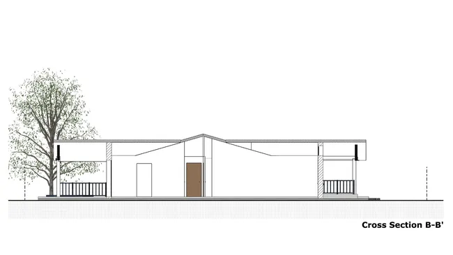
House cross section plan
Create multiple section cuts (such as one per orientation) and reveal wall construction details.
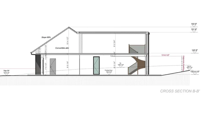
Section plan with annotations
Use clear annotations and callouts to highlight key data such as roof pitch percentage or notes about unused attic space.
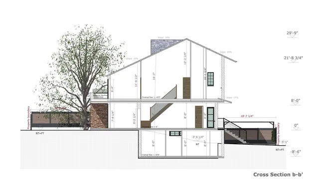
Cross section plan with elevation dimensions
Choose which manual dimensions to display on the section plan, along with property lines and vertical elevation benchmarks referenced to natural grade levels.
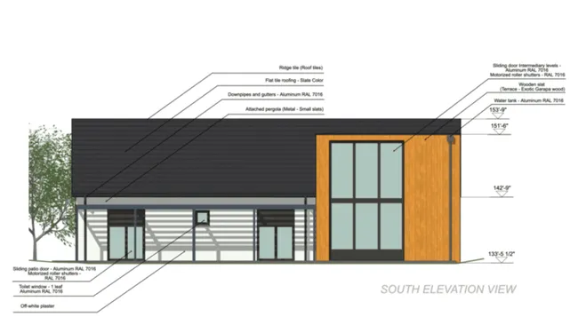
Elevation plan with annotations
Add as many annotations as needed and use arrows to call out information commonly required for construction teams such as exterior finishes, colors, materials, and more.
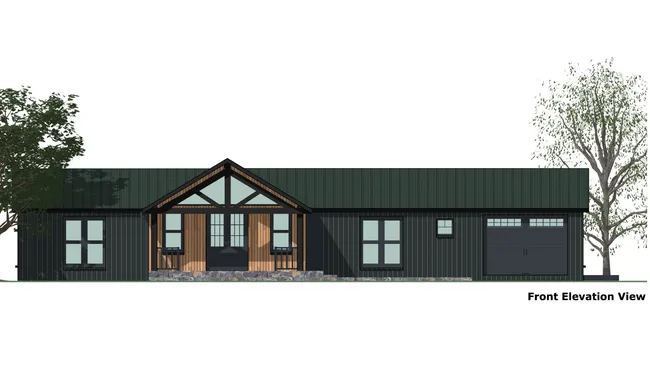
Elevation plan with architectural details
Show architectural elements such as handrail style, carport, pergola, security bars, roller shutters, and chimney designs on the elevation view.
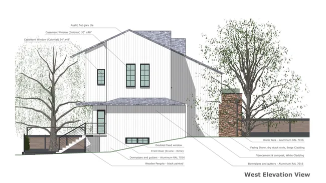
Elevation plan with exterior elements
Display fences, trees, and surrounding landscapes to present a realistic, complete elevation view of the project.
Frequently Asked Questions
Several elevation generator programs can produce section drawings. Cedreo is a cross section and elevation maker built for construction and renovation professionals and is used by thousands of builders and contractors.
With Cedreo, you create more than a single section plan. You can assemble everything needed for client presentations and planning submissions: scaled 2D floor plans, 3D plans, interior and exterior 3D renderings, site plans, elevation plans, and presentation documents for construction or remodeling projects.
Cedreo’s advanced features also make it easy to import existing plans as well as export and download detailed documents for construction teams.
With Cedreo’s section generator, creating a house cross section takes three simple steps:
- Start by tracing the building, select the composition of exterior and interior walls, draw terrain contours, then enter elevation lines or points (with coordinates if needed) and add the roof.
- To fine-tune the section for your needs, add symbols and text notes to provide specific information. Use the panel on the left side to adjust units, line weights, and other features with a click.
- Choose the section orientation and location, then set the framing (to include or exclude terrain and property lines) and name it. The section plan generates instantly.
If you change the drawing or finishes, the cross section plan updates automatically, making revisions easy.
In three steps, you can go from floor plan to elevation view with Cedreo’s elevation creator:
- Draw the project’s exterior and interior walls, and choose the windows, doors, and their colors.
- Cedreo simplifies roof design. The software identifies house contours. You just choose the roof type, then apply exterior finishes (stucco, siding, roofing type, etc.). You can also manually draw complex roofs.
- Once the project is complete, generate the elevation plan in a few clicks. Select the façade needed and adjust the framing (setbacks and which exterior elements to include or exclude).
- Then, annotate the elevation plan to specify items like roof pitch and the colors of finishes or windows and doors, and add it to project presentation documents. You can also set the scale and units, map out site elements, and export or download detailed elevations for your office or field teams.
Yes. Create an unlimited number of cross section plans and elevation views. You’ll see an overview of all plans for the same project, so it’s easy to click between views. To stay organized, give each view a title and choose whether to display it on the plan, then export any rectangle-framed view you need.
Yes. For a single project, you can create several versions of an elevation view, such as one version with annotations and dimensions, and another that shows only the graphic view without notes. This makes it simple to compare different types of designs and provide the right deliverable to each audience.
Choose the scale best suited to your document format and display it on the plan. Cedreo also makes it easy to add necessary details like dimensions, natural and finished ground contours, heights, and material characteristics.
It’s easy to use.
But you can always count on Cedreo support
For an even faster start, access tutorials and help articles.
Get tips to do more, faster.
“The ease of drawing the 2D layout plan was the main draw to this program. It was very intuitive compared to some other programs that were trialed.”